 W
WThe Castalian Spring, in the ravine between the Phaedriades at Delphi, is where all visitors to Delphi — the contestants in the Pythian Games, and especially pilgrims who came to consult the Delphic Oracle — stopped to wash themselves and quench their thirst; it is also here that the Pythia and the priests cleansed themselves before the oracle-giving process. Finally Roman poets regarded it as a source of poetic inspiration. According to some mythological versions it was here that Apollo killed the monster, Python, who was guarding the spring, and that is why it was considered to be sacred.
 W
WMount Giona is a mountain in Phocis, Central Greece. It is located between the mountains of Parnassus to the east, Vardousia to the west, and Oeta to the north. Known in classical antiquity as the Aselinon Oros, it is the highest mountain south of Olympus and the fifth overall in Greece. Pyramida is its highest peak at 2,510 metres (8,235 ft). Other peaks include the Perdika, Tragonoros, Platyvouna or Plativouna, Profitis Ilias, Kastro, Vraila, Paliovouni, Pyrgos, Lyritsa, Botsikas, Kokkinari, Tychioni and another Profitis Ilias. It is drained by the river Mornos to the west.
 W
WThe Gulf of Corinth or the Corinthian Gulf is a deep inlet of the Ionian Sea, separating the Peloponnese from western mainland Greece. It is bounded in the east by the Isthmus of Corinth which includes the shipping-designed Corinth Canal and in the west by the Strait of Rion which widens into the shorter Gulf of Patras and of which the narrowest point is crossed since 2004 by the Rio–Antirrio bridge. The gulf is bordered by the large administrative divisions : Aetolia-Acarnania and Phocis in the north, Boeotia in the northeast, Attica in the east, Corinthia in the southeast and south and Achaea in the southwest. The gulf is in tectonic movement comparable to movement in parts of Iceland and Turkey, growing by 10 mm (0.39 in) per year.
 W
WKallidromo is a mountain in southeastern Phthiotis and northeastern Phocis, in Central Greece. Its maximum elevation is 1,399 m. The Kallidromo lies south of the Malian Gulf, east of Mount Oeta and north of the Cephissus valley. The strategic site of Thermopylae lies north of the mountain. The village of Drymaia is on the mountain. Nearby places are Mendenitsa to the northeast and Amfikleia to the south. The Motorway 1 passes north of the mountain. The classic railway from Athens to Lamia and Thessaloniki passes south and west of the mountain, while the newer high-speed line passes through the mountain via a tunnel.
 W
WThe Mornos is a river in Phocis and Aetolia-Acarnania in Greece. It is 70 km (43 mi) long. Its source is in the southwestern part of the Oiti mountains, near the village Mavrolithari, Phocis. It flows towards the south, and enters the Mornos Reservoir near the village Lefkaditi. The dam was completed in 1979. It leaves the reservoir towards the west, near Perivoli. The river continues through a deep, sparsely populated valley, and turns south near Trikorfo. The lower course of the Mornos forms the boundary between Phocis and Aetolia-Acarnania. The Mornos empties into the Gulf of Corinth about 3 km southeast of Nafpaktos.
 W
WMount Oeta is a mountain in Central Greece. A southeastern offshoot of the Pindus range, it is 2,152 m (7,060 ft) high. Since 1966, the core area of the mountain is a national park, and much of the rest has been declared a special area under Natura 2000.
 W
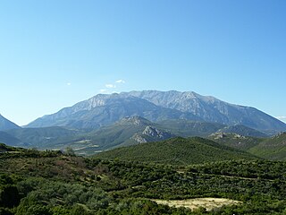
WMount Parnassus is a mountain of limestone in central Greece that towers above Delphi, north of the Gulf of Corinth, and offers scenic views of the surrounding olive groves and countryside. According to Greek mythology, this mountain was sacred to Dionysus and the Dionysian mysteries; it was also sacred to Apollo and the Corycian nymphs, and it was the home of the Muses. The mountain was also favored by the Dorians. It is suggested that the name derives from parnassas, the possessive adjective of the Luwian word parna meaning house, or specifically temple, so the name effectively means the mountain of the house of the god.
 W
WIn Greece, the Phaedriades are the pair of cliffs, ca 700 m high on the lower southern slope of Mt. Parnassos, which rise above the sacred site of Delphi. Strabo, Plutarch and Pausanias all mentioned the Phaedriades when describing the site, a narrow valley of the Pleistos formed by Parnassos and Mount Cirphis. Between them rises the Castalian Spring. Even nowadays, at noontime, the rock surfaces reflect a dazzling glare.
 W
WThe Pleistos is a river in central Greece. It rises at Mount Parnassos near the town Arachova, Boeotia. It flows west through a deep valley, between the mountains Parnassos and Kirphe, passing south of Delphi, through the Delphic Landscape and the plain of Amphissa and flows into the Corinthian Gulf near Kirra. The water of the Castalian Spring flow into Pleistos.
 W
WTrizonia is a small island in Corinthian Gulf and the only inhabited island among the islands of the Corinthian gulf. Along with the nearby islets Prasoudi, Planemi and Agios Ioannis comprise a small group of islands. It is located in the north coasts of Corinthian gulf opposite the villages Glyfada and Chania of Phocis prefecture. Its area is 2.5 square kilometers and its population is 64 inhabitants according to 2011 census. The island belongs to Dorida municipality in Phocis regional unit.
 W
WVardousia is a mountain in northwestern Phocis and southwestern Phthiotis, Greece. Its highest peak, Korakas reaches 2,495 m (8,186 ft) above sea level, making it the second-tallest summit in Central Greece after Giona. It is a southern extension of the Pindus mountains. It is divided into three main parts: Northern Vardousia, whose highest peak is Sinani at 2,059 metres, the very steep Western Vardousia, whose highest peak is Soufles at 2,300 metres, and Southern Vardousia, with the highest peak of Korakas. The whole range measures about 25 kilometres from north to south.