 W
WThe Gran Desierto de Altar is one of the major sub-ecoregions of the Sonoran Desert, located in the State of Sonora, in northwest Mexico. It includes the only active erg dune region in North America. The desert extends across much of the northern border of the Gulf of California, spanning more than 100 kilometres (62 mi) east to west and over 50 kilometres (31 mi) north to south. It constitutes the largest continuous wilderness area within the Sonoran Desert.
 W
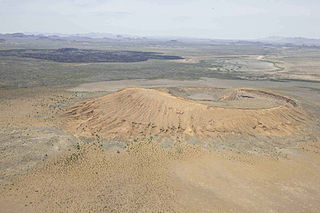
WThe Pinacate Peaks are a group of volcanic peaks and cinder cones located mostly in the Mexican state of Sonora along the international border adjacent to the U.S. state of Arizona, surrounded by the vast sand dune field of the Gran Desierto de Altar, at the desert's southeast.
 W
WEl Pinacate y Gran Desierto de Altar Biosphere Reserve is a biosphere reserve and UNESCO World Heritage Site managed by the Federal government of Mexico, specifically by Secretariat of the Environment and Natural Resources, in collaboration with state government of Sonora and the Tohono O'odham.
 W
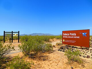
WCabeza Prieta National Wildlife Refuge (CPNWR) is located in southwestern Arizona in the United States, along 56 miles (90 km) of the Mexico–United States border. It is bordered to the north and to the west by the Barry M. Goldwater Air Force Range, to the south by Mexico's El Pinacate y Gran Desierto de Altar Biosphere Reserve, to the northeast by the town of Ajo, and to the southeast by Organ Pipe Cactus National Monument.
 W
WEl Camino del Diablo is a historic 250-mile (400 km) road that currently extends through some of the most remote and arid terrain of the Sonoran Desert in Pima County and Yuma County, Arizona. In use for at least 1,000 years, El Camino del Diablo is believed to have started as a series of footpaths used by desert-dwelling Native Americans. From the 16th to the 19th centuries, the road was used extensively by conquistadores, explorers, missionaries, settlers, miners, and cartographers. Use of the trail declined sharply after the railroad reached Yuma in 1870. In recognition of its historic significance, El Camino del Diablo was listed on the National Register of Historic Places in 1978. It has also been designated a Bureau of Land Management Back Country Byway.
 W
WEleodes is a genus of darkling beetles commonly known as pinacate beetles or desert stink beetles. They are endemic to western North America, with many species found in the Sonoran Desert. The name pinacate is Mexican Spanish, derived from the Nahuatl (Aztec) name for the insect, pinacatl, which translates as "black beetle".
WThe Pinacate Peaks are a group of volcanic peaks and cinder cones located mostly in the Mexican state of Sonora along the international border adjacent to the U.S. state of Arizona, surrounded by the vast sand dune field of the Gran Desierto de Altar, at the desert's southeast.
 W
WPsorothamnus spinosus, known as the smokethorn, smoketree, smoke tree, smokethorn dalea, and corona de Cristo, is a perennial legume tree of the deserts in North America.
 W
WPuerto Peñasco is a small city located in Puerto Peñasco Municipality in the northwest of the Mexican state of Sonora, 100 kilometres (62 mi) from the border with the U.S. state of Arizona. According to the 2015 census, it has a population of 62,177 inhabitants. It is located on the northern shores of the Sea of Cortez on the small strip of land that joins the Baja California Peninsula with the rest of Mexico. The area is part of the Altar Desert, one of the driest and hottest areas of the larger Sonoran Desert.
 W
WQuitobaquito Springs are springs in Organ Pipe Cactus National Monument in Pima County, Arizona. The name is of Tohono O'odham origin meaning 'house ring spring'. The area has been populated for at least 16,000 years. It lies at an elevation of 1,152 feet (351 m), west of the south end of the Quitobaquito Hills, along the border of the United States with Mexico. The only US populations of the endangered Quitobaquito pupfish, the Sonoyta mud turtle, the desert caper, and the Howarth's white butterfly are found here. The Quitabaquito tryonia is an endemic resident of the springs.
 W
WThe Valley and range sequence-Southern Yuma County is a 3-Valley sequence of NW–by–SE trending block faulted valleys and mountains. About eleven major mountain ranges connect to each other in four,, mountain sequences.