 W
WChoiyoi Group is a Permian and Triassic-aged group of volcano-sedimentary formations in Argentina and Chile. The group bears evidence of bimodal-style volcanism related to an ancient subduction zone that existed along the western margin of the supercontinent Gondwana.
 W
WThe Drakensberg is the name given to the eastern portion of the Great Escarpment, which encloses the central Southern African plateau. The Great Escarpment reaches its greatest elevation – 2,000 to 3,482 metres within the border region of South Africa and Lesotho.
 W
WEagle Heights is an elevated area located south of Koksilah Ridge on Vancouver Island, British Columbia, Canada. It is centered at 48°40′N, 123°46′W. Its summit lies about 836 meters above sea level. Populated areas where it is visible include North Saanich, Sidney, and Shawnigan Lake.
 W
WThe Karmutsen Formation is a Late Triassic volcanic sequence of tholeiitic pillow basalts and breccias on Vancouver Island, British Columbia, Canada. It is perhaps the thickest accreted section of an oceanic plateau worldwide, exposing up to 6000 m of basal sediment-sill complexes, basaltic to picritic pillow lavas, pillow breccia, and thick, massive basalt flows. The widespread succession of basalts and breccias are part of the Insular Mountains, a large volcanic mountain range that forms Vancouver Island and Haida Gwaii. In Strathcona Provincial Park, pillow basalts is the most abundant rock unit. About half the mountains, including the highest ones, are carved from these basalts, such as Golden Hinde, which is the highest peak on Vancouver Island.
 W
WNorth Mountain is a narrow southwest-northeast trending volcanic ridge on the mainland portion of southwestern Nova Scotia, stretching from Brier Island to Cape Split. It forms the northern edge of the Annapolis Valley along the shore of the Bay of Fundy. Together with South Mountain, the two ranges form the Annapolis Highlands region.
 W
WThe Ochoco Mountains are a mountain range in central Oregon in the United States, located at the western end of the Blue Mountains. They were formed when Permian, Triassic, and Jurassic rocks were slowly uplifted by volcanic eruptions to form the Clarno Formation. Today, the highest point in the range is Lookout Mountain. The dominant vegetation on the west side of the range is old-growth ponderosa pine; on the east side, western juniper is common. The western area of the mountains is administered by the Ochoco National Forest, while the southeastern section is part of the Malheur National Forest. The Ochoco Mountains are used for hiking, camping, bird watching, rockhounding, and hunting, as well as cross-country skiing in the winter.
 W
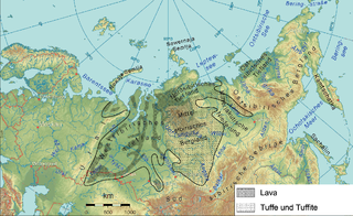
WThe Siberian Traps is a large region of volcanic rock, known as a large igneous province, in Siberia, Russia. The massive eruptive event that formed the traps is one of the largest known volcanic events in the last 500 million years.
 W
WMount Tom, 1,202 feet (366 m), is a steep, rugged traprock mountain peak on the west bank of the Connecticut River 4.5 miles (7 km) northwest of downtown Holyoke, Massachusetts. The mountain is the southernmost and highest peak of the Mount Tom Range and the highest traprock peak of the 100-mile (160 km) long Metacomet Ridge. A popular outdoor recreation resource, the mountain is known for its continuous line of cliffs and talus slopes visible from the south and west, its dramatic 1,100-foot (340 m) rise over the surrounding Connecticut River Valley, and its rare plant communities and microclimate ecosystems.
 W
WThe Watchung Mountains are a group of three long low ridges of volcanic origin, between 400 and 500 feet high, lying parallel to each other in northern New Jersey in the United States. The Watchung Mountains are known for their numerous scenic vistas overlooking New York City, Newark and New Jersey skylines, as well as their isolated ecosystems containing rare plants, endangered wildlife, rich minerals, and globally imperiled trap rock glade communities. The ridges traditionally contained the westward spread of urbanization, forming a significant geologic barrier beyond the piedmont west of the Hudson River; the town of Newark, for example, once included lands from the Hudson to the base of the mountains. Later treaties moved the boundary to the top of the mountain, to include the springs.
 W
WThe Wrangellia Terrane is a terrane extending from the south-central part of Alaska through southwestern Yukon and along the Coast of British Columbia in Canada. Some geologists contend that Wrangellia extends southward to Oregon, although this is not generally accepted.