 W
WThe Temblor Range is a mountain range within the California Coast Ranges, at the southwestern extremity of the San Joaquin Valley in California in the United States. It runs in a northwest-southeasterly direction along the borders of Kern County and San Luis Obispo County. The name of the range is from Spanish temblor meaning "tremor", referring to earthquakes. The San Andreas Fault Zone runs parallel to the range at the base of its western slope, on the eastern side of the Carrizo Plain, while the Antelope Plain, location of the enormous Midway Sunset, South Belridge, and Cymric oil fields, lies to the northeast.
 W
WBitterwater Creek, originally named Arroyo de Matarano, is a stream in eastern San Luis Obispo County and northwestern Kern County, central California.
 W
WThe Carrizo Plain (Obispeño: tšɨłkukunɨtš, "Place of the rabbits"; is a large enclosed grassland plain, approximately 50 miles long and up to 15 miles across, in southeastern San Luis Obispo County, California, about 100 miles northwest of Los Angeles. It contains the 246,812-acre Carrizo Plain National Monument, and it is the largest single native grassland remaining in California. It includes Painted Rock in the Carrizo Plain Rock Art Discontiguous District, which is listed on the National Register of Historic Places. In 2012 it was further designated a National Historic Landmark due to its archeological value. The San Andreas Fault occurs along the eastern edge of the Carrizo Plain at the western base of the Temblor Range.
 W
WThe Cholame Hills are a low mountain range in extreme southeastern Monterey County, California.
 W
WThe Cymric Oil Field is a large oil field in Kern County, California in the United States. While only the 14th-largest oil field in California in total size, in terms of total remaining reserves it ranks fifth, with the equivalent of over 119 million barrels (18,900,000 m3) still in the ground. Production at Cymric has been increasing faster than at any other California oil field.
 W
WThe McKittrick Oil Field is a large oil and gas field in western Kern County, California. The town of McKittrick overlies the northeastern portion of the oil field. Recognized as an oil field in the 19th century, but known by Native Americans for thousands of years due to its tar seeps, the field is ranked 19th in California by total ultimate oil recovery, and has had a cumulative production of over 303 million barrels (48,200,000 m3) of oil. The principal operators of the field as of 2008 were Chevron Corp. and Aera Energy LLC, but many independent oil exploration and production companies were also active on the field. The California Department of Oil, Gas and Geothermal Resources (DOGGR) estimates approximately 20 million recoverable barrels of oil remain in the ground.
WMedia Aqua Creek, originally Aguaje de en Media, is a creek in northwestern Kern County and eastern San Luis Obispo County, central California.
 W
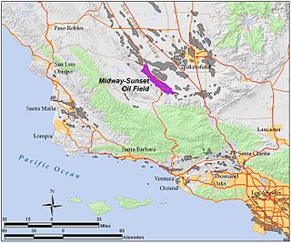
WThe Midway-Sunset Oil Field is a large oil field in Kern County, San Joaquin Valley, California in the United States. It is the largest known oilfield in California and the third largest in the United States.
 W
WParkfield is an unincorporated community in Monterey County, California. It is located on Little Cholame Creek 21 miles (34 km) east of Bradley, at an elevation of 1,529 feet (466 m). As of 2007 road signs announce the population as 18.
 W
WReward is an unincorporated community in western Kern County, California.