 W
WThe Brahmaputra Valley is a region situated between hill ranges of the eastern and northeastern Himalayan range in Eastern India.
 W
WChinta Valley is a valley and a village located 20 kilometres (12 mi) northeast of Bhaderwah town on Bhaderwah-Jai road. It is covered with thick coniferous forests from all sides with a stream flowing through it known as Chinta Nallah. A village called Thuba divides the valley from Bhaderwah.
 W
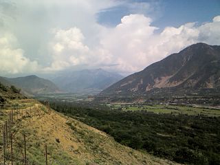
WJai Valley is an enchanting valley located 32 kilometres (20 mi) northeast of Bhaderwah town. The Bhaderwah-Jai road, which passes through the corniferous deodar forests of Nakshri, Balote, Bhalara and Chinta Valley connects the valley with the Bhaderwah town. The valley has green meadows which act as the attraction for tourists in summers and the snow-covered landscape during winters. Jai valley has about 9 kilometres (5.6 mi) long meadows, bisected by a stream called Jai Nallah which merges with a tributary of river Chenab at Kahara in tehsil Thathri. It is also known by the names Jai Garh and Jai Top. The valley is also connected through a 37 kilometres (23 mi) long road with Gandoh.
 W
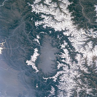
WThe Kashmir Valley, also known as the Vale of Kashmir, is an intermontane valley in the portion of the Kashmir region administered by India. The valley is bounded on the southwest by the Pir Panjal Range and on the northeast by the main Himalayas range. It is approximately 135 km (84 mi) long and 32 km (20 mi) wide, and drained by the Jhelum River.
 W
WKharahal is one of the valleys in Kullu District of Himachal Pradesh, India. It is situated on the left bank of the Bias River. Kharahal is famous for two temples: Bijli Mahadev and Ma Durga.
 W
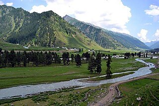
WThe Lidder Valley or Liddar Valley in the union territory of Jammu and Kashmir, India, is a Himalayan sub-valley that forms the southeastern corner of the Kashmir Valley. The Lidder River flows down the valley. The entrance to the valley lies 7 km northeast from Anantnag town and 62 km southeast from Srinagar, the summer capital of Jammu and Kashmir. It is a 40-km-long gorge valley with an average width of 3 km.
 W
WThe Lolab Valley is a Himalayan valley located in Jammu and Kashmir, India. The entrance to the valley lies 9 km (5.6 mi) north of Kupwara town, and the centre of the valley lies 114 km (71 mi) northwest of Srinagar, the capital of Jammu and Kashmir. It is an oval-shaped valley 15 miles (24 km) long with an average width of 2 miles (3.2 km).
 W
WThe Sind Valley is a Himalayan sub-valley of the Kashmir Valley in the Indian union territory of Jammu and Kashmir. The entrance of the Sind Valley lies 33 kilometres (21 mi) northeast of Srinagar the capital of Jammu and Kashmir. It is a 65 kilometres (40 mi) long gorge valley with an average width of 1 kilometre (0.62 mi).
 W
WThe Tulail Valley is a Himalayan sub-valley of Gurez in the union territory of Jammu and Kashmir in India. The Valley lies 120 kilometres (75 mi) northeast of Bandipora and 200 kilometres (120 mi) from Srinagar the capital of Jammu and Kashmir.
 W
WThe Warwan Valley is a Himalayan sub-valley and a tehsil in Kishtwar District in the union territory of Jammu and Kashmir in India. The Valley lies 68 kilometres (42 mi) northeast of Kishtwar and 150 kilometres (93 mi) from Srinagar the capital of Jammu and Kashmir.