 W
WThe Ochoco National Forest is located in the Ochoco Mountains in Central Oregon in the United States, north and east of the city of Prineville, location of the national forest headquarters. It encompasses 850,000 acres (3,440 km2) of rimrock, canyons, geologic oddities, dense pine forests, and high desert terrain, as well as the headwaters of the North Fork Crooked River. A 1993 Forest Service study estimated that the extent of old growth in the forest was 95,000 acres (38,000 ha).
 W
WAntelope Flat Reservoir is an impoundment located in the southern part of the Maury Mountains in Crook County, Oregon. It is formed by a 33-foot (10 m) high earth-fill dam built across Bear Creek for irrigation purposes. The western part of the lake is within the Ochoco National Forest. Though it covers 170 acres (69 ha) when full, and has a storage capacity of almost 2,000 acre feet (2,500,000 m3) with a maximum depth of 28 feet (8.5 m) and average depth of 11 feet (3.4 m), the reservoir is often not filled to capacity, especially late in the irrigation season. The lake resides at an elevation of 4,984 feet (1,519 m). A boat-launch ramp is located at the lake's western end, and a 25-unit campground lies just up the hill from there.
 W
WThe Black Canyon Wilderness of Oregon is a wilderness area in the Ochoco National Forest. It is within the drainage basin of the South Fork John Day River. It lies in Grant and Wheeler counties in Oregon. The nearest city is Paulina, in Crook County. It was established in 1984 and encompasses 13,400 acres (5,423 ha).
 W
WBridge Creek Wilderness is a wilderness area located in the Ochoco Mountains of central Oregon, within the Ochoco National Forest. It was established in 1984 and comprises 5,400 acres (2,185 ha), making it one of the smallest Wilderness areas in the state.
 W
WCrooked River National Grassland is a National Grassland located in Jefferson County in the north-central part of the U.S. state of Oregon. It has a land area of 173,629 acres (70,265 ha). It contains two National Wild and Scenic Rivers, the Deschutes River and the Crooked River. The grassland is managed together with the Ochoco National Forest from Forest Service offices in Prineville. There are local ranger district offices located in Madras, its nearest city.
 W
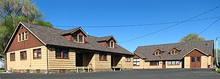
WThe Lamonta Compound – Prineville Supervisor's Warehouse is a complex of buildings and related infrastructure owned an operated by the Ochoco National Forest in Prineville, Oregon, United States. Built by the Civilian Conservation Corps in 1933–1934, it is the headquarters for field operations in the national forest and is typical of projects carried out by the CCC on behalf of the Forest Service. It represents that era's shift in the Forest Service's architectural vision toward comprehensive site planning, as well as its policy evolution from custodial superintendence of the national forests toward active natural resource management.
WThe Maury Mountains are a mountain range in Crook County, Oregon. Much of the range is within the Ochoco National Forest. Outstanding features of the range are the Maury Mountains Agate Beds and Antelope Flat Reservoir.
 W
WMill Creek Wilderness is a wilderness area located in the Ochoco National Forest of central Oregon. It was established in 1984 and comprises 17,400 acres (7,040 ha). Of the three wilderness areas in the Ochoco National Forest - Mill Creek, Bridge Creek, and Black Canyon - Mill Creek is the largest and most heavily used.
 W
WThe Ochoco Mountains are a mountain range in central Oregon in the United States, located at the western end of the Blue Mountains. They were formed when Permian, Triassic, and Jurassic rocks were slowly uplifted by volcanic eruptions to form the Clarno Formation. Today, the highest point in the range is Lookout Mountain. The dominant vegetation on the west side of the range is old-growth ponderosa pine; on the east side, western juniper is common. The western area of the mountains is administered by the Ochoco National Forest, while the southeastern section is part of the Malheur National Forest. The Ochoco Mountains are used for hiking, camping, bird watching, rockhounding, and hunting, as well as cross-country skiing in the winter.
WThe Oregon Star Party (OSP) was founded in 1987 and is considered one of the best annual events in the United States for observational astronomy. The Oregon Star Party takes place in the Ochoco National Forest, near the geographical center of the state of Oregon. It is far enough from population centers to provide some of the darkest skies in North America. The area's 5,000-foot (1,500 m) altitude contributes to steady seeing, which frequently provides near ideal observational conditions. The OSP site also has a treeless field of view providing an unobstructed 360 degree horizon.