 W
WLewis and Clark National Forest is located in west central Montana, United States. Spanning 2,912 square miles (7,500 km2), the forest is managed as two separate zones. The eastern sections, under the Jefferson Division, is a mixture of grass and shrublands dotted with "island" pockets of forested areas. Here, cattle leases to local ranchers as well as timber harvesting are the norm. The western Rocky Mountain Division, which straddles the Continental divide, is managed chiefly for environmental preservation, as much of the land has been designated as wilderness. Forest headquarters are located in Great Falls, Montana. Local ranger district offices have been established in Choteau, Harlowton, Neihart, Stanford, and White Sulphur Springs.
 W
WThe Bob Marshall Wilderness Area is a Congressionally designated wilderness area located in western Montana in the United States. It is named after Bob Marshall (1901–1939), an early forester in the federal government, conservationist, and co-founder of The Wilderness Society. In the 1930s while working for the US Forest Service, Marshall was largely responsible for designation of large areas to be preserved as roadless within lands administered by the U.S. Forest Service; he achieved this through promulgation of various regulations. Formally designated in 1964, the Bob Marshall Wilderness extends for 60 miles (95 km) along the Continental Divide and consists of 1,009,356 acres (4,085 km²).
 W
WThe Castle Mountains, highest point Elk Peak, el. 8,589 feet (2,618 m), are an island range east of White Sulphur Springs in Meagher County, Montana, United States. About 30,000 acres of the Castles were roadless as of 1995. The western portion of the Castles are moist, while the eastside is dry, porous limestone hills. The range gets its name from "castle turrets", 50-foot high igneous rock spires on the western slopes. The range was the focus of mining activity in the previous century; crumbling remains of old miners' cabins and diggings are present throughout the area. The landscape is characterized by a central cluster of peaks over 8,000 feet and extensive grassy parks surrounded by lodgepole pine and limber pine. The Castles are lightly used by recreationists except for hunters in the fall. On the peak of Castle Mountain itself is a login book for the few who reach the top. There is no trail that leads to the peak.
 W
WThe Crazy Mountains, often called the Crazies, are a mountain range in the northern Rocky Mountains in the U.S. state of Montana.
 W
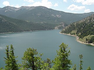
WGibson Reservoir is a man-made body of water located just south of the Bob Marshall Wilderness, 20 miles (32 km) northwest of Augusta, Montana. It forms part of the county line between Teton and Lewis & Clark counties. The reservoir is formed by the concrete arch Gibson Dam and backs water up between a hilly pass for about 3 miles. The water in the dam is initially provided by spring snow runoff and carried there via the North Fork Sun River and the South Fork Sun River right after the two join. The reservoir is mainly used for irrigation control.
 W
WThe Little Belt Mountains are a section of the Rocky Mountains in the U.S. state of Montana. Situated mainly in the Lewis and Clark National Forest, the mountains are used for logging and recreation for the residents of Great Falls, Montana. Showdown is a ski area located within the mountains located off US Highway 89 which splits the mountains in half connecting White Sulphur Springs and Belt, MT. The highest point in the Little Belt Range is Big Baldy Mountain at 9,175 feet (2,797 m).
 W
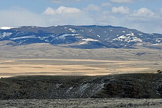
WThe Little Snowy Mountains are a small mountain range in central Montana about 25 miles (40 km) southeast of Lewistown. The range lies mostly in Fergus County, but the southern part of the range extends into Golden Valley and Musselshell counties.
 W
WThe Lump Gulch Fire was a wildfire that burned in Jefferson County in the state of Montana in the United States. The fire, which was first reported on June 13, 2020, was started by a downed power line. It burned in the Lewis and Clark National Forest, Helena National Forest, and on state and private land. As of June 23, the fire had burned 1,079 acres (437 ha) and was 85 percent contained. Two outbuildings were destroyed by the fire and select areas on National Forest land were closed due to the fire.
 W
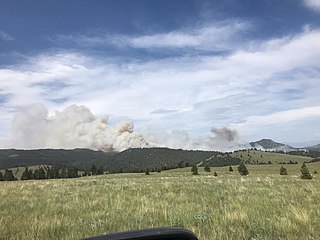
WThe Park Creek Fire was a wildfire located two miles north of Lincoln in Helena National Forest and Lewis and Clark National Forest in Montana in the United States. The fire, which was reported on July 14, 2017, was started by lightning and burned over 18,000 acres (73 km2). It threatened the community of Lincoln and directly impacted recreational activities in the national forests.
 W
WThe Scapegoat Wilderness consists of 239,936 acres (971 km2) spread across three different National Forests in the U.S. state of Montana. Created by an act of Congress in 1972, the wilderness is located in Lewis and Clark, Helena and Lolo National Forests. The Scapegoat Wilderness is a part of the 1.5 million acre (6,070 km2) Bob Marshall Wilderness Complex as it shares a boundary with the Bob Marshall Wilderness, which in turn is connected to the Great Bear Wilderness further north.