 W
WAkkadō (安家洞) is a limestone cavern located in the town of Iwaizumi, Iwate Prefecture in the Tōhoku region of northern Japan. It has a measured length of 23,702 metres (77,762 ft), which makes it the longest in Japan. The cave system was designated as a Natural monument by the Japanese government in 1980. Since 1991, a portion of the caverns have been open to the public for part of the year.
 W
WCape Todo , also written as "魹ヶ崎" is the easternmost point of the island of Honshu in Japan. It is located within the borders of the city of Miyako, Iwate, and is part of the Sanriku Fukkō National Park. Although referred to as a “cape”, the area is not clearly a peninsula extending into the Pacific Ocean, but is simply the easternmost point on a coastline.
 W
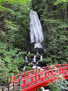
WFudō Falls is a waterfall in the city of Hachimantai, Iwate Prefecture, Japan, on a branch of the Api River.
 W
WGenbikei (厳美渓) is a two kilometer long ravine on the Iwai River in the city of Ichinoseki, Iwate Prefecture, Japan. It has been designated a National Place of Scenic Beauty and Natural Monument since 1927.
 W
WJōdogahama (浄土ヶ浜) is a series of rock formations along the coast of Miyako Bay in the city of Miyako, Iwate Prefecture, in the Tōhoku region of northern Japan. The area is part of the Sanriku Fukkō National Park, and is a nationally designated Place of Scenic Beauty.
 W
WLake Furukawanuma was a lake that existed in Rikuzentakata, Iwate, Japan until March 11, 2011. When the 2011 Tohoku earthquake struck, the resulting tsunami destroyed the sand wall that separated the lake from the sea. The lake's western edge thus became part of the new coastline, and the lake became part of the sea.
 W
WThe Mabechi River is a river located in northern Iwate Prefecture and eastern Aomori Prefecture, in the Tōhoku region of northern Honshū in Japan.
 W
WMiyako Bay is a bay in Iwate Prefecture, in the northern Tōhoku region of northern Japan. It is a long and narrow, roughly triangular body of water extending southwest to northeast where it opens to the Pacific Ocean. The Omoe Peninsula forms its southern border and Cape Anegasaki forms its southern border. This gives it an area of approximately 24 km2 (9.3 sq mi).
 W
WRyūsendō (龍泉洞) is one of Japan's three largest limestone caverns. It is located in the town of Iwaizumi, Iwate Prefecture, in the Tōhoku region of northern Japan.
WThe Sanriku Coast is a coastal region on the Pacific Ocean, extending from southern Aomori Prefecture, through Iwate Prefecture and northern Miyagi Prefecture in northeastern Honshū, which is Japan's main island. The name comes from the historical region of Sanriku, referring to the former provinces of Rikuō, Rikuchū and Rikuzen.