 W
WAn ice cap is a mass of ice that covers less than 50,000 km2 (19,000 sq mi) of land area. Larger ice masses covering more than 50,000 km2 (19,000 sq mi) are termed ice sheets.
 W
WThe Cook Ice Cap or Cook Glacier is a large ice cap in the Kerguelen Islands in the French Southern Territories zone of the far Southern Indian Ocean.
 W
WEyjafjallajökull is one of the smaller ice caps of Iceland, north of Skógar and west of Mýrdalsjökull. The ice cap covers the caldera of a volcano with a summit elevation of 1,651 metres (5,417 ft). The volcano has erupted relatively frequently since the Last Glacial Period, most recently in 2010, when, although relatively small for a volcanic eruption, it caused enormous disruption to air travel across western and northern Europe for a week.
 W
WLangjökull is the second largest ice cap in Iceland (953 km2), after Vatnajökull. It is situated in the west of the Icelandic interior or Highlands of Iceland and can be seen clearly from Haukadalur.
 W
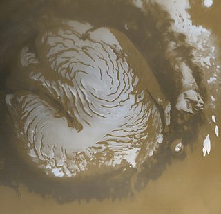
WThe planet Mars has two permanent polar ice caps. During a pole's winter, it lies in continuous darkness, chilling the surface and causing the deposition of 25–30% of the atmosphere into slabs of CO2 ice (dry ice). When the poles are again exposed to sunlight, the frozen CO2 sublimes. These seasonal actions transport large amounts of dust and water vapor, giving rise to Earth-like frost and large cirrus clouds.
 W
WMýrdalsjökull is an ice cap in the south of Iceland. It is to the north of Vík í Mýrdal and to the east of the smaller ice cap Eyjafjallajökull. Between these two glaciers is Fimmvörðuháls pass. Its peak reaches 1,493 m (4,898 ft) in height and in the year 1980 it covered an area of approximately 595 km2 (230 sq mi).
 W
WA polar ice cap or polar cap is a high-latitude region of a planet, dwarf planet, or natural satellite that is covered in ice.
 W
WThe Peruvian Quelccaya Ice Cap is the second largest glaciated area in the tropics, after Coropuna. Located in the Cordillera Oriental section of the Andes mountains, the cap covers an area of 42.8 square kilometres (16.5 sq mi) with ice up to 200 metres (660 ft) thick. It is surrounded by tall ice cliffs and a number of outlet glaciers, the largest of which is known as Qori Kalis Glacier; lakes, moraines, peat bogs and wetlands are also present. There is a rich flora and fauna, including birds which nest on the ice cap. Quelccaya is an important source of water, eventually nourishing the Inambari and Vilcanota Rivers.
 W
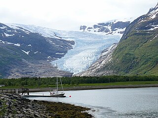
WSvartisen is a collective term for two glaciers located in Nordland county in northern Norway. It is part of Saltfjellet-Svartisen National Park, located in the Saltfjell mountain range. The glaciers are located in the municipalities of Beiarn, Meløy, Rana, and Rødøy. Svartisen consists of two separate glaciers that are separated by the 1-kilometre (0.62 mi) long Vesterdalen valley. The two glaciers are:Vestisen or Vestre Svartisen has an area of 221 square kilometres (85 sq mi) which makes it the second largest glacier on the Norwegian mainland after the Jostedalsbreen glacier. Østisen or Østre Svartisen has an area of 148 square kilometres (57 sq mi) which makes it the country's fourth largest glacier.
WVatnajökull is the largest and most voluminous ice cap in Iceland, and the second largest in area in Europe after the Severny Island ice cap of Novaya Zemlya. It is in the south-east of the island, covering approximately 8% of the country.