 W
WThe Aral Sea was an endorheic lake lying between Kazakhstan and Uzbekistan which began shrinking in the 1960s and had largely dried up by the 2010s. The name roughly translates as "Sea of Islands", referring to over 1,100 islands that had dotted its waters. In the Mongolic and Turkic languages aral means "island, archipelago". The Aral Sea drainage basin encompasses Uzbekistan and parts of Tajikistan, Turkmenistan, Kyrgyzstan, Kazakhstan, Afghanistan, and Iran.
 W
WThe Aral–Caspian Depression is a lowland depression straddling Europe and Asia around the Aral Sea and Northern Caspian Sea. The most northern part is called the Caspian Depression. The desert part to the east of the Caspian Depression and Caspian is called the Turan Depression. In Azerbaijan, the Kura-Aras Lowland is part of the Aral–Caspian Depression.
 W
WThe Aralkum Desert is a desert that has appeared since 1960 on the seabed once occupied by the Aral Sea. It lies to the south and east of what remains of the Aral Sea in Uzbekistan and Kazakhstan.
 W
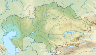
WBarsa-Kelmes Nature Reserve is a wildlife refuge on the former island of Barsa-Kelmes in Kyzylorda Region of Kazakhstan, in Central Asia.
 W
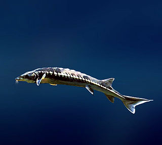
WThe bastard sturgeon, fringebarbel sturgeon, ship sturgeon, spiny sturgeon, or thorn sturgeon is a species of fish in the family Acipenseridae. Formerly abundant in the Black, Aral and Caspian seas, its range is now primarily limited to the Ural River, with possible relict populations in the Rioni River in Georgia and the Safid Rud in Iran. The healthiest population is one in Lake Balkhash in Kazakhstan, well outside its natural range, where they were introduced in the 1960s for commercial purposes. It has been reported that this fish has the highest relative fecundity for any sturgeon species.
 W
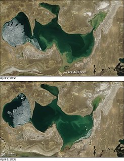
WDike Kokaral is a 12 km long dam across a narrow stretch of the Aral Sea, splitting off the North Aral Sea from the much larger South Aral Sea. The dike is conserving the dwindling waters of the Syr Darya river and maintaining the damaged ecology of the North Aral Sea, at the expense of sealing the fate of the larger South Aral. Work was completed in August 2005, with help from the World Bank. Dike Kokaral is named after the Kokaral peninsula, which would connect it to the other shore of the Aral Sea and separate the northern from the southern seas.
 W
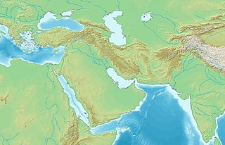
WKhwarazm, or Chorasmia, is a large oasis region on the Amu Darya river delta in western Central Asia, bordered on the north by the (former) Aral Sea, on the east by the Kyzylkum desert, on the south by the Karakum desert, and on the west by the Ustyurt Plateau. It was the center of the Iranian Khwarazmian civilization, and a series of kingdoms such as the Khwarazmian dynasty and the Afrighid dynasty, whose capitals were Kath, Gurganj and – from the 16th century on – Khiva. Today Khwarazm belongs partly to Uzbekistan and partly to Turkmenistan.
WThe North Aral Sea is the portion of the former Aral Sea that is fed by the Syr Darya River. It split from the South Aral Sea in 1987–1988 as water levels dropped due to river diversion for agriculture. The poorly built Dike Kokaral intended to contain the North Aral Sea and save its fisheries failed twice, but in 2005, the government of Kazakhstan was able to fund a more robust design. Since then, water levels have risen faster than expected and fish stocks have increased. Plans to build a second dike to increase water levels further were due to begin in 2010, but have so far not materialized.
WThe South Aral Sea was a lake in the basin of the former Aral Sea which formed in 1987 when that body divided in two, due to diversion of river inflow for agriculture. In 2003, the South Aral Sea itself split into eastern and western basins, the Eastern Sea and the West Aral Sea, connected by a narrow channel that balanced surface levels but did not allow mixing, and in 2005 the North Aral Sea was dammed to prevent the collapse of its fisheries, cutting off the only remaining inflow to the southern lakes. In 2008, the Eastern Sea split again, and in May 2009 had almost completely dried out, leaving only the small permanent Barsakelmes Lake between the Northern and Western Seas and increasing the expanse of the Aralkum desert. In 2010, it was partially filled again by meltwater, and by 2014 was once again dry. The West Aral Sea has some replenishment from groundwater in the northwest, and so is likely to avoid desiccation.
 W
WZhalanash, is a village in south central Kazakhstan. Previously a fishing village on the Aral Sea, Zhalanash now lies several kilometers from its shores. In recent years, it had become a tourism location for its old harbor, where several ship hulls had been left standing in the desert by the retreating sea. As of 2017, these hulls have been dismantled for scrap metal and only the bottoms remain. The town's economy is focused around camel herding.